Oshkosh, Wisconsin, United States
London, United Kingdom
Reykjavík, Iceland
New York, United States
Singapore, Singapore

Scroll to zoom, drag to pan, double-click to reset.
24c WeatherPreview
For pilots first — and anyone who looks up at the sky.
Free demo — no account needed.
Preview: the dial is real, and the way in is an invitation. Write to mat@24c.day and tell us where you would use it.
Make it yours
Loading the model's settings…
The legend
Hover the dial to see what each part is. Click to pin it; Escape lets go.
Legend
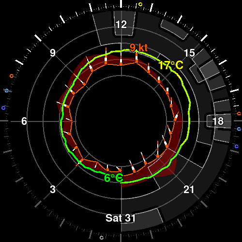
A 24 hour window on the sky you fly in. Cloud by altitude, wind as instruments around the rim, the freezing level, visibility and the light — not a flight plan, just the day's air, always there when you look up. Built for pilots first, with no membership test for everyone else who loves the wind.
Wind socks every hour, with gust stripes
Freezing level, visibility and precipitation, each on its own scale
Sunrise, sunset and the twilights on the rim
Your calendar's events, so a flight fits around the day
Settings for the ceiling, the clock's orientation and units
The sun's ring
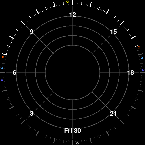
The rim is the day's light, and its dots are a compass.
The four bands are daylight, civil twilight, nautical twilight and night. The orange, azure, and blue dots mark sunrise/sunset, civil dawn/dusk, and nautical dawn/dusk respectively. The yellow dot is solar noon: point the time arrow in the direction of shadows, and the yellow dot will point north*.
White dots indicate 5 minutes, small ticks 15m, larger ticks 30m, and bold ticks 1hr
in the northern hemisphere. In the southern, point the yellow dot at the sun and the arrow will point north
The sun rose at 06:50 and set at 16:37, 9h 47m of daylight; solar noon was at 11:44.
London · 30 Oct 2026 · computed sun
Cloud by altitude
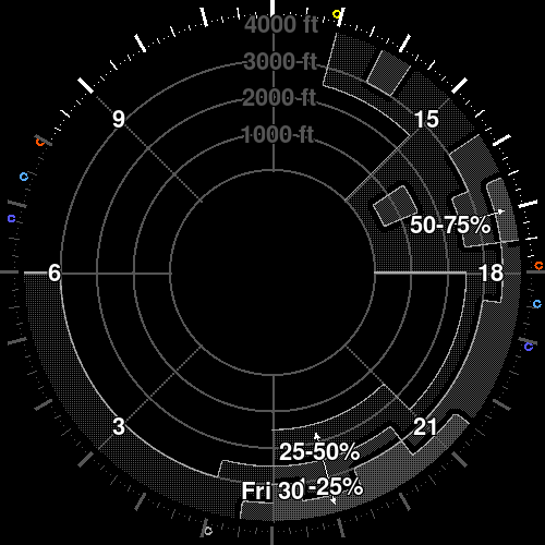
The grey texture is cloud, and the rings give it a height.
Denser means more of the sky is covered. The altitude rings are labelled in thousands of feet, so a deck can be read against the ground and the ceiling rather than guessed at.
Cloud cover reached 63% around 17:00, with the densest cover in the high altitude bands.
Vancouver · 30 Oct 2026
Freezing level
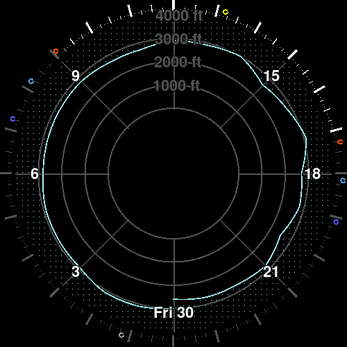
The pale line is the height where the air reaches zero.
Above it, snow and ice live; below it, the air is above freezing. It shares the altitude axis with the cloud, so the line and the deck can be read against each other.
The freezing level started at 3,100 ft at midnight, fell to 2,500 ft around 20:00, and ended at 2,700 ft.
Reykjavík · 30 Oct 2026
Visibility
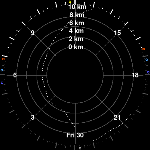
The pale line is how far the air lets you see horizontally.
Visibility is a distance, not a height: the line runs from 0 to 10 km on its own scale. Lower means haze, fog or a hard horizon; higher means the air is clear. It is not read against the altitude rings.
Visibility was worst at 1.0 km around 05:00, and reached 10.0 km around 13:00.
London · 30 Oct 2026
Temperature
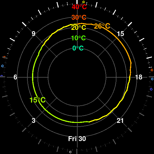
The colour ring is the air temperature through the day.
The line runs from 0 °C at the inside to 40 °C at the outside; a day below zero mirrors back out, and the colour says which side of zero it is. The coldest and warmest values are printed on the line.
The air temperature ranged from 15.0 °C at 04:00 to 26.0 °C at 13:45.
Lisbon · 30 Oct 2026
UV
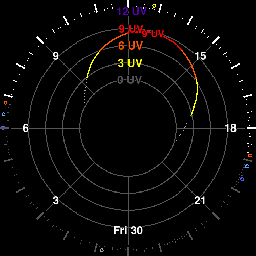
The inner line is the UV index, in the WHO's bands.
Zero is at the inside, twelve at the outside. The line steps through the bands rather than sliding, and the day's peak is printed where it happens.
UV peaked at 8.9 — very high — around 13:00.
Singapore · 30 Oct 2026
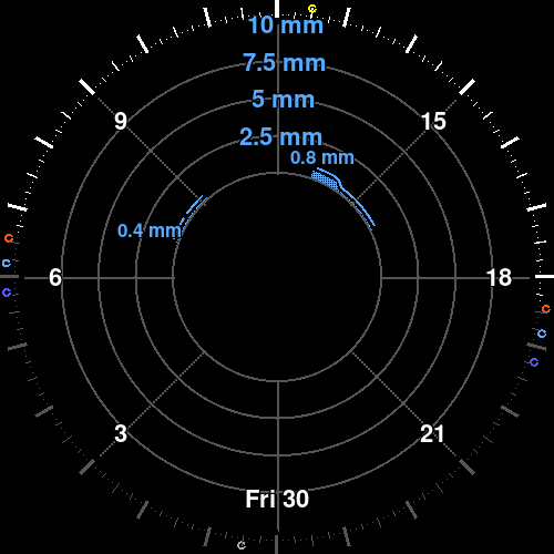
Rain, snow and storms
The bars are precipitation, coloured by what is falling.
Rain, snow and ice each have their own colour; the labels print the rate at the peaks, and a bolt marks a thunderstorm where the report carries one. The same dial shows every phase because the weather does.
Precipitation fell in 2 spells over 20 quarter-hours, 2.4 mm in total; the heaviest quarter-hour was at 13:15, about 0.8 mm/h.
Lagos · 30 Oct 2026
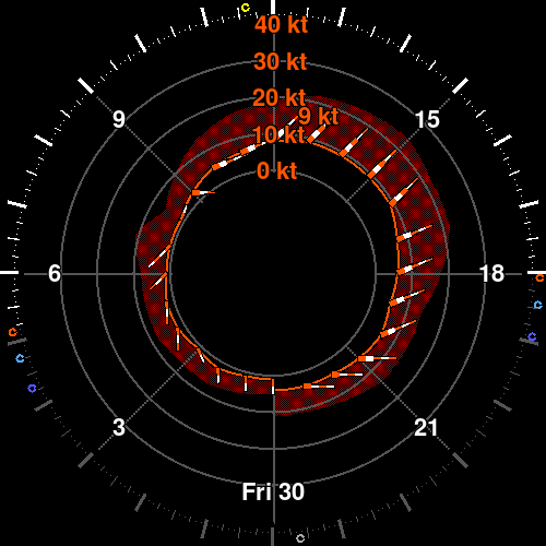
Wind
Every sock points downwind; its bands count the knots.
The orange sock is the mean wind, the darker stripes are the gusts, and the strongest wind of the day is printed where it peaks. North is up, so the sock is also a direction.
The mean wind peaked at 9 kt around 13:00; gusts reached 24 kt.
Rio de Janeiro · 30 Oct 2026
24c Weather
The whole day, one picture, no scrolling.
For pilots first — and anyone who looks up at the sky.
Specs
| Model | 24c Weather |
|---|---|
| Window | 24 hours, one local day |
| Altitude axis | Ground to 40,000 ft, default 4,000 ft |
| Wind | 10 m, knots, 3 kt segments with gust stripes |
| Precipitation | Quarter-hourly, three phases and a thunderstorm hazard |
| Cloud | 12 altitude bands, dithered in oktas |
| Calendar | ICS subscription or Google Calendar |
| Output | Square dial, 64 – 4096 px |
| Palette | 64 colours (RGB222), hard edges, no blends |
| Refresh | Clients poll every 5 minutes |
| Data | Weather forecast |
Get it
Garmin
Connect IQ watchface
Store links come with the first release.
Android
Wear OS watchface and widget
Store links come with the first release.